Mynd:Pacific Ring of Fire.png
Stærð þessarar forskoðunar: 800 × 593 mynddílar Aðrar upplausnir: 320 × 237 mynddílar | 640 × 475 mynddílar | 1.024 × 760 mynddílar | 1.046 × 776 mynddílar.
Upphafleg skrá (1.046 × 776 mynddílar, skráarstærð: 66 KB, MIME-gerð: image/png)

|
File:Pacific Ring of Fire.svg is a vector version of this file. It should be used in place of this PNG file.
File:Pacific Ring of Fire.png → File:Pacific Ring of Fire.svg
For more information, see Help:SVG. |
 |
Lýsing
| Lýsing |
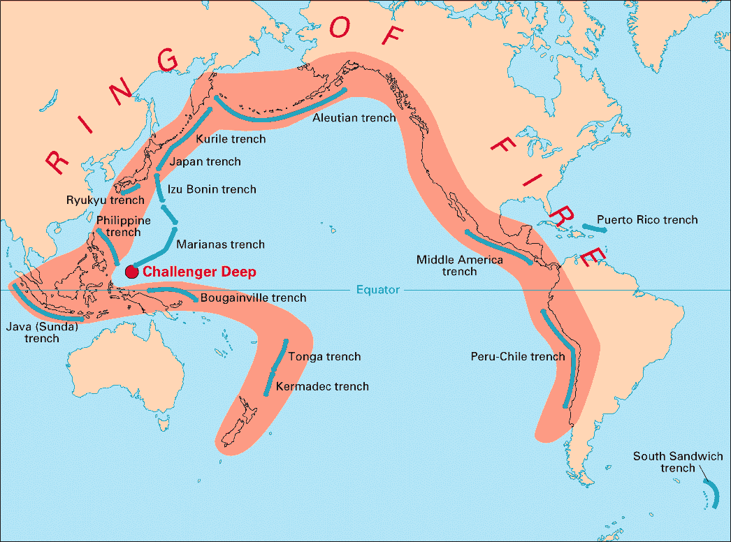
English: Volcanic arcs and oceanic trenches partly encircling the Pacific Basin form the so-called Pacific Ring of fire, a zone of frequent earthquakes and volcanic eruptions. The trenches are shown in blue-green. The volcanic island arcs, although not labelled, are parallel to, and always landward of, the trenches. For example, the island arc associated with the Aleutian Trench is represented by the long chain of volcanoes that make up the Aleutian Islands. |
| Dagsetning | |
| Uppruni | http://pubs.usgs.gov/publications/text/fire.html |
| Höfundarréttarhafi | USGS |
Leyfisupplýsingar:
This image is in the public domain in the United States because it only contains materials that originally came from the United States Geological Survey, an agency of the United States Department of the Interior. For more information, see the official USGS copyright policy.
|
Breytingaskrá skjals
Smelltu á dagsetningu eða tímasetningu til að sjá hvernig hún leit þá út.
| Dagsetning/Tími | Smámynd | Víddir | Notandi | Athugasemd | |
|---|---|---|---|---|---|
| núverandi | 28. desember 2004 kl. 03:28 | | 1.046 × 776 (66 KB) | Ævar Arnfjörð Bjarmason | Deeper colours |
| 28. desember 2004 kl. 03:26 |  | 1.046 × 776 (156 KB) | Ævar Arnfjörð Bjarmason |
Skráartenglar
Það eru engar síður sem nota þessa skrá.
Altæk notkun skráar
Eftirfarandi wikar nota einnig þessa skrá:
- Notkun á als.wikipedia.org
- Notkun á ar.wikipedia.org
- Notkun á ary.wikipedia.org
- Notkun á bs.wikipedia.org
- Notkun á ca.wikipedia.org
- Notkun á da.wikipedia.org
- Notkun á dsb.wikipedia.org
- Notkun á en.wikipedia.org
- Notkun á en.wikibooks.org
- Notkun á eo.wikipedia.org
- Notkun á eu.wikipedia.org
- Notkun á fr.wikipedia.org
- Notkun á gl.wikipedia.org
- Notkun á hr.wikipedia.org
- Notkun á hsb.wikipedia.org
- Notkun á id.wikipedia.org
- Notkun á it.wikipedia.org
- Notkun á ko.wikipedia.org
- Notkun á ko.wikinews.org
- Notkun á lt.wikipedia.org
- Notkun á lv.wikipedia.org
- Notkun á mg.wikipedia.org
- Notkun á ms.wikipedia.org
- Notkun á nia.wikipedia.org
- Notkun á nl.wikipedia.org
- Notkun á nn.wikipedia.org
- Notkun á no.wikipedia.org
- Notkun á pap.wikipedia.org
- Notkun á pnb.wikipedia.org
- Notkun á ro.wikipedia.org
- Notkun á simple.wikipedia.org
- Notkun á sk.wikipedia.org
- Notkun á sl.wikipedia.org
- Notkun á sr.wikipedia.org
- Notkun á su.wikipedia.org
- Notkun á sv.wikipedia.org
Skoða frekari altæka notkun þessarar skráar.