Mynd:Bl-map.png
Það er engin hærri upplausn til.
Bl-map.png (327 × 350 mynddílar, skráarstærð: 12 KB, MIME-gerð: image/png)

|
This locator map image could be re-created using vector graphics as an SVG file. This has several advantages; see Commons:Media for cleanup for more information. If an SVG form of this image is available, please upload it and afterwards replace this template with
{{vector version available|new image name}}.
It is recommended to name the SVG file “Bl-map.svg”—then the template Vector version available (or Vva) does not need the new image name parameter. |
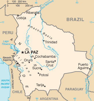
Lýsing
| Lýsing | Bolivia map from CIA World Factbook (since 2. júní 2004), converted from original GIF format |
| Dagsetning | |
| Uppruni |
CIA World Factbook |
| Höfundarréttarhafi | United States Central Intelligence Agency |
| Aðrar útgáfur |
Leyfisupplýsingar:
This image is in the public domain because it contains materials that originally came from the United States Central Intelligence Agency's World Factbook.
|
 |
Derivative works
-
 Bl-map mk.png
македонски -
 Bolivie carte.gif
français -
 Bolivyaharita.jpg
Türkçe -
 Ka Bolivia-Map.png
ქართული


Breytingaskrá skjals
Smelltu á dagsetningu eða tímasetningu til að sjá hvernig hún leit þá út.
| Dagsetning/Tími | Smámynd | Víddir | Notandi | Athugasemd | |
|---|---|---|---|---|---|
| núverandi | 17. júní 2008 kl. 09:15 | | 327 × 350 (12 KB) | Sevela.p | Remove black line on the left side |
| 27. febrúar 2005 kl. 17:52 |  | 328 × 350 (12 KB) | Alfio | CIA map of Bolivia |
Skráartenglar
Eftirfarandi síða notar þessa skrá:
Altæk notkun skráar
Eftirfarandi wikar nota einnig þessa skrá:
- Notkun á af.wikipedia.org
- Notkun á ar.wikipedia.org
- Notkun á ast.wikipedia.org
- Notkun á ay.wikipedia.org
- Notkun á be.wikipedia.org
- Notkun á bn.wikipedia.org
- Notkun á bn.wikibooks.org
- Notkun á bo.wikipedia.org
- Notkun á ca.wikipedia.org
- Notkun á cs.wikipedia.org
- Notkun á da.wikipedia.org
- Notkun á de.wikibooks.org
- Notkun á de.wikinews.org
- Notkun á dsb.wikipedia.org
- Notkun á dz.wikipedia.org
- Notkun á el.wikipedia.org
- Notkun á en.wikipedia.org
- List of islands of South America
- Talk:Geography of Bolivia
- Outline of Bolivia
- Irrigation in Bolivia
- Water resources management in Bolivia
- Agriculture in Bolivia
- Module:Location map/data/Bolivia/doc
- Module:Location map/data/Bolivia
- User:Gonzalezmwalter/Bolivia and the International Monetary Fund
- User:Gonzalezmwalter/IMF Bolivia
- Bolivia and the International Monetary Fund
- Notkun á en.wikibooks.org
- Notkun á en.wikinews.org
- Notkun á en.wikisource.org
- Notkun á eo.wikipedia.org
Skoða frekari altæka notkun þessarar skráar.